Chamäleon Observatory HOME
|
||||||
Small Vulcanic Structures on the near side of the Moon observed with an Earth based medium size Amateur Telescope Lunar Domes, Pyroclastic Areas of Deposit, Plateaus, Megadome Plateaus Sinusoidal Lava Tubes and Floor Fractured Craters |
||||||
| Wolfgang Paech + Franz Hofmann / Last Update: 12.01.2018 / Contact |
 |
This site shows a large part of the front
of the moon at an intervall of about 24 hours and a moon age from 3.3 to 14.8
days (12 - 100% illumination) with special attention to small structures lunar
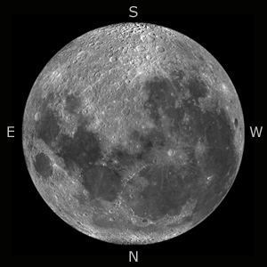
volcanism in high resolution. The orientation of the images is different from the modern representations in lunar atlases. They are orientated in the same way as the CCD camera captures the images in the focus of the telescope - SOUTH is up and EAST is LEFT. The image resolution is on average between 1,000 to 2,000 meters, whereas for some images - depending on the lunar distance, the position of the details in viewing direction to the earth and the illumination - it is even under 1,000 meters. Height differences of about 50 m are visible. Another lunar atlas showing normal lunar structures such as craters, rilles, mountains ... we present here. Two examples perfectly illustrate the high image resolution: The "Floor Fractured" crater Alphonsus with rilles and pyroclastic volcanism and the two lunar Cones Isis and Osiris in the Mare Tranquillitatis southwest of the landing area of Apollo 17. |
| Nearly all images are from 2015, taken
in the months of July, August and September. A few images from the years 2007
to 2014 and 2016 were included due to special illumination situations. With
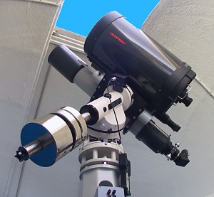
very few exceptions, the images were taken in the focus of a Celestron C14 (f =
3.900 mm) with a Celestron SkyRis 445M video module. A Baader IR pass filter
was used to optimize the seeing for all recordings. Location of the telescope
were two guest farms in Namibia: the Rooisand Desert Ranch (2007 to 2011) and
from 2013 the Onjala Lodge near Windhoek. A very small part of the images was taken at the 430mm (f / 6.8) PlaneWave astrograph of the Rooisand Desert Ranch, partly recorded with a Baader Q - Turett Barlow lens ( f approximately 4.500 mm ). The video streams have been processed with a standard recording method and a standardized image processing mode. The summed images were created with the software AviStack 1.8, the final processing was done in Adobe Photoshop CS 2. The length of each video stream was between 1200 and 1500 frames - depending on the seeing conditions. 12 % of the frames were added to the final image. |
 |
|
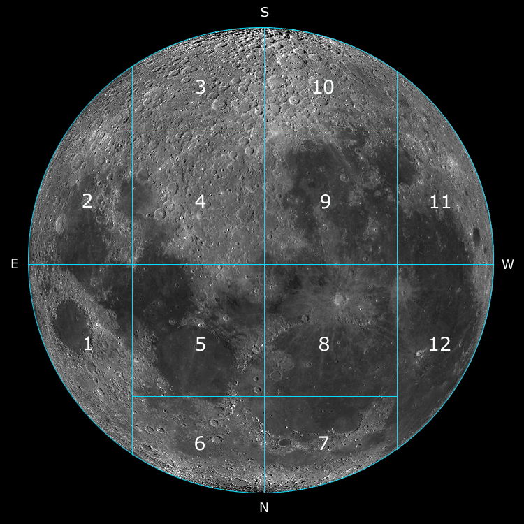
Choose one of the following segments: Segment 01: Mare Crisium, Mare Undarum, Geminus, Proclus, Mesalla, Cauchy Region Segment 02: Mare Fecunditatis, Messier, Petavius, Langrensus, Furnerius, Vallis Rheita Segment 03: Highland regions around the craters Janssen, Stöffler und Maurolycus Segment 04: Western part of Mare Nectaris, Theophilus, Fracastorius, Piccolomini, Albategnius, Deslandres, Walter Segment 05: Mare Tranquilitatis, Mare Serenitatis, Posidonius, Aristillus, Autolycus. Gardner, Jansen, landing site of Apollo 15+17 Segment 06: Eastern part of Mare Frigoris, Atlas, Herkules, Endymion, Aristoteles, Eudoxus, Lacus Mortus Segment 07: Northern part of Mare Imbrium, western part of Mare Frigoris, Plato, Sinus Iridum Segment 08: Mare Imbrium, Archimedes, Erathostenes, CoperniCus, Apenninen Segment 09: Mare Nubium, Eastern part Mare Humorum, Lansberg, M. Riphaeus, Pitatus, Bullialdus Segment 10: Highlands, Tycho, Clavius, Newton, Heinzel, Mee Segment 11: Western part of Mare Humorum, Schickard, Gassendi, Crüger, Billy, Grimaldi Segment 12: Oceanus Procellarum, Sinus Roris, Kepler, Reiner, Marius Hills, Aristarch Plateau DOWNLOAD: pdf-file with a list of all volcanic structures of this lunar atlas (only in german language) |
| < © NASA/LRO |
| Wavelength in nanometer |
Celestron 14, aperture 350mm resolution in arcseconds |
Planewave Astrograph, aperture 430mm resolution in arcseconds |
| blue, 400 nm | 0.23 | 0.18 |
| green, 550 nm | 0.31 | 0.25 |
| red, 680 nm | 0.40 | 0.33 |
1 km on the Moon (in the middle of the Moon) corresponds to 0.56" or 1" corresponds to1.8 km. Therefore, 1 pixel in the image corresponds to 375 meters on the Moon (theoretically), practically in the red wavelength region around 750 meters. These theoretical calculated values are strongly valid only for a point light source. The field which is shown in the focus of the Celestron 14 is (slightly) cropped about 5.4 x 4.0 arcmin, corresponding to 324 x 240 arcsec.
On some images objects are selected, which are not listed in the official lists of volcanic structures, but morphologically, they are very similar to the known structures. They are then either labeled with a "?" or marked with the word "putative". There is also a hint in the corresponding description.
| Does the practice also correspond to the theory? Here are some Examples of achieved image resolution in practice. |
Basic preconditions for successful observations are therefore:
- low solar elevation at the chosen structure on the Moon
- for observation: a clear sky and almost darkness
- very good to excellent seeing conditions.
Lunarer volcanism - a short overview
Like on Earth, the lunar volcanism can be roughly structured into the following basic types:
- Effusive volcanism
- Intrusive and extrusive volcanism
- Pyroclastic (explosiv) volcanism
- a mixture of them.
- Lunar Domes/lunar Cones
- Super-, Megadomes, Megadomeplateaus
- Lunar pyroclastic deposits
- Floor fractured crater (FFC)
- Dark halo crater (DHC, DMD = Dark mantle deposits) and
- Sinuous rilles
- Lunar Kipukas
- Concentric double craters and the
- Aristarch plateau
| Literature: Our website is based on the work of Raffaello Lena, Maria Teresa Chiocchetta, Mike Wirths, Paolo Lazzarotti, Jim Phillips, Carmelo Zannelli, Stefan Buda and George Tarsoudis. They are a loose group of amateur astronomers, who specialized on the observations of lunar volcanism. All geometric data, coordinates, diameter, height and classification of lunar domes on our website based on their work. It is summarized and referenced to many scientific results in lunar research in the book: |
The website of the Geological Lunar Researches Group (GLR) can be found here and a list of publications here. There is also a website with a list of lunar domes.
Further literature:
This is the website with the interactive map of the Moon of the Lunar Reconnaissance Orbiters Team. It provides direct access to any lunar formation, starting with a scale of 4 km per pixel. You can zoom in to a magnification of 64 meters per pixel for the images taken with the wide-angle camera, followed by the image strips of the tele camera where the scale is up to 1 meter per pixel. In addition, you can switch on various overlays like digital elevation models. All images that we have included into this lunar atlas are marked with LRO. General information on this NASA spacecraft can be found here.
At http://www.avistack.de you can download the video image processing program which we have used to process the moon images. It has been programmed by Dr. Michael Theusner and is freeware. See also our page for image processing.
Highly recommended literature and lunar atlases:
 |
Charles A. Wood: The Modern Moon: A Personal View, Sky Publishing
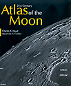
Corporation, 2005 Charles A. Wood, Maurice Collins: 21st Century Atlas of the Moon, West Virginia University Press, 2012 Motomaro Shirao, Charles A. Wood: The Kaguya Lunar Atlas: The Moon in High Resolution, Springer, 2011 |
 |
W.
Paech, M. Weigand und A. Chu: Fotografischer Mondatlas: 69 Mondregionen in
hochauflösenden Fotos, Oculum, 2010 A. Chu, W. Paech, M. Weigand und S. Dunlop: The Cambridge Photographic Moon Atlas, Cambridge University Press, 2012 |
 |
The
following two publications are pdf-files and free for download. Both - Alan
Chus Photographic Moonbook and K.C. Paus Photographic Lunar Atlas for Moon
Observers - are modern milestones in amateur moon observation. Mr. Chu is also
a member of the Hong Kong Astronomical Society and both are observing from Hong
Kong Alan Chu: Photographic Moonbook (version 3.5, edition 2011, 260 pages) K.C. Pau: Photographic Lunar Atlas for Moon Observers (Second edition 2016, 900 pages) |
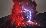 |
And Last but not least we would like to thank Mr. Martin Rietze for his support regarding terrestrial volcanism. He belongs to the world's best photographers of terrestrial volcanism and is author of some books of this topic. A visit of his website is breath-taking. |